Crannogs
Crannogs On the Web - Tiree
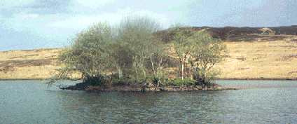
Eilean Mhic Conuill, Loch Bhasapol
Surveyed May 22, 1995
NGR: NL 9698 4677
This site, identified by RCAHMS (1980, no. 246(2)) is located 82.0 m S of the large peninsula in the W end of Loch Bhasapol. At the time of survey the site was totaly submerged. The section of lochbed surrounding the site is composed of firm sand with a slight growth of vegetation and reviled no trace of a suspected causeway. At the time of survey the top of the site was covered by 0.3 m of water and showed no signs of vegitational growth. The site is surrounded by water 1.2 m to 1.5 m in depth but deepens to 2.3 m between the site and shore.
The artificial island is a circular mound of small, well rounded stone which measures 31.6 m by 34.5 m at its base. The mound is capped by a fairly level, circular platform which measures 24.0 m in diameter and stands 1.0 m above the surrounding lochbed. The sides of the mound taper out gradually at an angle of 6 degrees over and average of 5.0 m. No walling, shaped stone or timbers were found.
Crannogs On the Web - Mull
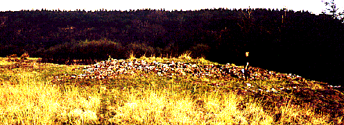
Gruline Crannog, Loch Ba
Surveyed March 12, 1994
NGR: NM 513 392
Another site listed as a probable crannog (RCAHMS card file NM 53 NE 3) is located at the extreme N end of Loch Ba, between Gruline House and the outlet of the River Ba . It consists of a circular mass of rubble, 15 m in diameter and 2 m high. At least 50% of the stone is too large for a man to lift, and ranges greatly in size. No timbers, cut stone or other features were found.
Access to this site wasdenied by the land owner.
Crannogs On the Web - Islay
Surveyed May 9, 1996
NGR: NR 40655 71236
This artificial island is located 45m off the W side of Loch Staoisha near the mid-point of the loch. The artificial islet is a nearly circular, stone-covered mound with a diameter of 24m at it’s base. The sides of the islet are a mass of stone rubble which breaks sharply, at an 18° angle, with the surrounding lochbed. The upper platform which crowns the top of islet is roughly circular in shape and has a diameter of 14.3m. At the time of survey, the upper platform stood 2.6m above the surrounding lochbed, 1.1m above the water-level, and was heavily overgrown with bushy vegetation and several large willow trees. The foundations of a pentagonal shaped structure, measuring 5.8m NW-SE by 4m NE-SW, were found near the centre of the islet. The foundations measured a maximum of 0.3m in height and consisted of a single course of medium sized stone.
Crannogs On the Web - Mull
Loch Na Meal Crannog
Surveyed March 10, 1994
NGR: NM 518 527
The Crannogs of Mull were first brought to public notice in 1870 by Mr. F. Campbell who discovered an artificial island after draining a loch located near the village of Tobermory. In 'The Proceedings of The Society of Antiquaries' (Campbell 1870) Mr. Campbell wrote that, upon draining Loch Na Meal, for farming purposes, he discovered what he described as "one of the artificial islands which are found in almost all the lochs of Mull." Mr. Campbell notes that Loch Na Meal, which means 'loch of deer', was fifty acres in size, about six feet deep and had a bed of mud several feet deep.
In order to aid the draining of the loch, ditches were dug around the premier. It was during this operation that a dugout log canoe was discovered between the island and the shore. The canoe was located four feet under the surface mud and appeared to be made of black oak. It measured seventeen feet in length, three and a half feet in width and was described as being quite fresh and sound. Several other smaller canoes, along with three modern clinker built boats, were also found nearer the surface of the mud but were not studied as they were in a half decayed state. Campbell submerged the principal Canoe near the Tobermory pier in order to preserve it from cracking, but by 1883 it had disappeared.
Campbell also found, what he described as "a stone causeway laid upon oak trees." (Campbell 1870) This feature, which was also four feet below the surface mud, ran directly from the shore to the island. The crannog was described as a quantity of loose stones which sat on the only rock near the surface of the loch. Local Geography - Loch Na Meal is located 2 km Southeast of Tobermory amid the stepped hills which dominate northern Mull. As mentioned above, the section of the loch which contains the crannog site has been drained. Surrounding land areas have been forested by The Forestry Commission and are highly disturbed.
The artificial island can now be found standing on a bedrock outcrop 1.3 m above a section of boggy ground 200 m north east of the present shoreline of Loch Na Meal. The structure takes the form of an oval shaped spread of stone, measuring 14 x 19 m at its base. A roughly level, oval, grass- covered platform is located at the centre of the structure. This platform measures 6 x 12 m, and stands 1.0 m above the bottom of the crannog. The area of platform is 49 square meters. No features were noted on this platform, however, the presence of the grass covering may indicate organic material still remains below it. When the Royal Commission surveyed the site in May of 1974 (RCAHMS 1980), they found that the platform measured 6 x 6.8 m and was delimited by intermittent paving stones. These stones were carefully examined but did not appear to be a concentric feature or paving.
A strange circular spur of loose stone, 4.5 m in diameter, projects from the west side of the crannog, facing what would have been open water. This platform is located 0.83 m below the level of the upper platform indicating that water levels would have to be at least 1 m below the top of the crannog for this area to be dry. It seems likely that the platform was part of the living area as it appears to be deliberately built and takes a shape which natural stone tumbling would not. If this platform had been above the water line, it would add 16 square meters of useable area to the crannog. It is possible that the platform might have been a working or storage area, though there is no proof of this as yet.
Another stone covered platform, similar to the first and roughly the same size, can be found projecting from the south east quadrant of the crannog. This platform is roughly level with the first and has a surface area of 15 square meters. Behind this platform are two short sections of dry stone walling which still remain standing. The walling is comprised of stone identical to that found in other areas of the crannog. The east section is five courses high, 0.5 m, and seems to run in a straight line for 1.792 m. The areas at the ends of the wall are masses of stone tumble which may have been continuations of the walling.
The west section of the walling stands three courses high, 0.4m and is 1.635 m long. It takes the shape of an arc which has its base directly under the upper platform. This section may have been part of a circular stone structure, the base of which stone tumble obscures. Such radial circular structures have been found on artificial islands located on Lewis in the Outer Hebridies (Armit 1990). Minimal stone shifting showed that the two sections of walling do connect and continue down for at least 0.5 m. Proper excavation would be needed to determine if the wall was part of a dwelling or exactly what its function was.
Crannogs On the Web - Islay

Surveyed May 15, 1996
NGR: NR 38675 67377
Eilean Mhuirell is located 51m from the SE shore of Loch Finlaggan. At the time of survey, the depth of the water immediately surrounding the site was between 1.5m and 2m, with water 3+ m in depth immediately to the N and E of the islet. Eilean Mhuirell is an oval shaped mound of stone which measures 30m NW-SE by 51m NE-SW at its base, with its long axis running parallel with the S shore of Loch Finlaggan. The surface of the islet is covered with a mixture of 80% medium-sized stone and 20% large boulders. The upper platform which stands 2.5m above the surrounding loch bed is also oval in shape measuring 17.5m NE-SW by 12.5m NW-SE. The turf-covered remains of a substantial perimeter wall could be traced around the margin of the upper platform. It was not possible to make an accurate measurement of the width of the wall due to the density of the undergrowth. At the time of survey, the surface of the islet was covered with a dense growth of briars and thorns and a small tree had taken root on the S side of the site. No traces of a causeway was found connecting the site to shore.
The remains of one of the sub-rectangular buildings (building a) previously noted by the RCAHMS were still visible through the undergrowth, however the other structure (building b)was completely obscured by briars and turf. The remains of what the RCAHMS described as a boat-noost were observed in the NW sector of the site. This feature was a slight depression in the islet’s surface which was most pronounced at the water-line but which continued down to the bottom of the islet’s stone covering. The depression was 2.7m in average width but only 0.4m in average depth.